


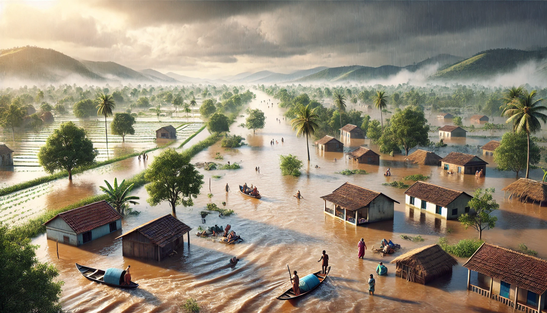
Have you ever wondered why floods wreak havoc in some parts of India every year? With its vast network of rivers, diverse landscapes, and monsoonal rains, India is particularly vulnerable to devastating floods.
From riverine deluges in Assam to urban waterlogging in Chennai, these disasters affect millions of lives, causing displacement, economic losses, and environmental damage.
Why are certain areas like the Brahmaputra Valley or the Ganga Basin more prone to flooding? What role do human activities and climate change play in intensifying this crisis?
Understanding India’s most flood-prone regions is vital for effective disaster management and preparedness. This blog explores the top 10 flood-affected areas and their underlying causes.
Why Are Floods a Recurring Problem in India?
Floods in India are caused by a combination of natural and human factors. The monsoon season brings heavy rainfall, which overwhelms rivers, particularly in low-lying floodplains. Major river basins like the Ganga, Brahmaputra, and Mahanadi have vast catchment areas prone to flooding.
Deforestation and unregulated urbanization exacerbate the problem by reducing natural water absorption and clogging drainage systems. Climate change adds another layer of complexity, leading to erratic weather patterns and rising sea levels.
Poor dam management and encroachments on natural water bodies further worsen the situation. Addressing these challenges requires a mix of sustainable land-use planning, reforestation, improved infrastructure, and flood forecasting systems.
Which Areas in India Are Most Prone to Flooding?
India’s flood-prone regions are largely concentrated around major river basins and coastal areas. Assam’s Brahmaputra Valley experiences severe riverine floods due to monsoonal rains and glacial melting.
Bihar faces recurring floods in the Kosi River Basin, while Uttar Pradesh suffers from frequent inundations in the Ganga Basin.
West Bengal is affected by both riverine floods and coastal storms, particularly in the Sundarbans region. Kerala’s coastal plains and Mumbai’s urban areas are frequently flooded during the monsoon season.
Odisha, with its Mahanadi Basin and cyclone-prone coastline, also sees regular flooding. Identifying and addressing the vulnerabilities in these regions is crucial for effective disaster management.
What Role Does Climate Change Play in Increasing Floods?
Climate change is a major driver of more frequent and intense floods in India. Rising global temperatures lead to increased glacier melting, adding to river volumes. Sea levels are rising, which causes coastal flooding during storms and high tides.
Climate change also intensifies monsoons, leading to heavier and more unpredictable rainfall. Cyclones, fueled by warmer ocean temperatures, bring devastating floods to coastal areas like Odisha and West Bengal.
These effects make existing flood management systems inadequate. Mitigating climate change through reforestation, reducing carbon emissions, and adopting climate-resilient infrastructure is vital to manage its impact on floods.
Top 10 Flood Prone Areas in India
1. Assam and the Brahmaputra Valley
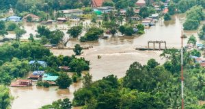
Image – Source
Assam, located in northeastern India, is one of the most flood-prone regions in the country. The Brahmaputra Valley, which cuts through the heart of the state, plays a significant role in its recurring flood disasters.
The Brahmaputra River is among the largest and most dynamic rivers in the world, and its annual swelling during the monsoon season leads to widespread devastation in Assam.
Reasons for Flooding in Assam:
- Monsoon Rains: The region receives heavy monsoonal rainfall from June to September, resulting in the Brahmaputra River and its tributaries overflowing their banks.
- Riverbank Erosion: Continuous erosion along the Brahmaputra’s banks reduces land stability, exacerbating flood risks.
- Glacial Melting: Melting glaciers in the Himalayas feed the river, adding to its water volume, particularly during warmer months.
- Topography: Assam’s low-lying terrain and floodplains make it naturally susceptible to waterlogging and inundation.
Impacts of Flooding:
- Human Displacement: Thousands of families lose their homes each year due to rising waters.
- Agricultural Losses: The fertile fields of Assam often remain submerged, leading to crop failures.
- Damage to Infrastructure: Roads, bridges, and communication networks suffer extensive damage.
Mitigation Efforts:
The Brahmaputra floods are not just a natural calamity but also a socio-economic crisis that affects millions of people annually. Efforts to mitigate these floods involve better embankment systems, early warning mechanisms, and sustainable land-use practices. However, challenges persist due to the river’s unpredictable behavior and the state’s limited resources.
2. Bihar and the Kosi River Basin
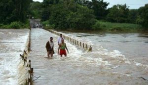
Image – Source
Bihar, situated in eastern India, is another region severely affected by recurrent flooding. The Kosi River, a tributary of the Ganga, is infamously known as the “Sorrow of Bihar” due to its unpredictable and devastating floods.
The river originates in the Himalayas, making it prone to heavy siltation and frequent course changes, further complicating flood management in the state.
Reasons for Flooding in the Kosi River Basin:
- Heavy Rainfall: Intense monsoonal rains, especially in the river’s catchment areas in Nepal, result in high inflows into the Kosi.
- Siltation: The river carries enormous amounts of silt from the Himalayas, raising its bed and reducing its water-holding capacity.
- Unpredictable Course Changes: The Kosi has shifted its course multiple times over centuries, inundating vast stretches of land.
- Dam Management Issues: Mismanagement of water released from upstream dams, particularly in Nepal, has also exacerbated flooding.
Impacts of Flooding:
- Widespread Destruction: Annual floods submerge large parts of northern Bihar, displacing millions.
- Agricultural Damage: The region’s agrarian economy takes a massive hit as floods destroy standing crops and disrupt planting cycles.
- Health Hazards: Stagnant floodwaters lead to waterborne diseases such as cholera and typhoid, affecting public health.
- Economic Losses: Infrastructure, including roads and schools, suffers extensive damage, leading to long-term recovery costs.
Mitigation Efforts:
Efforts to mitigate the Kosi floods include embankments and flood control projects, but these measures have met with limited success.
Experts emphasize the need for cross-border cooperation between India and Nepal, effective silt management, and community-based disaster preparedness to tackle the recurring floods in Bihar.
3. Uttar Pradesh and the Ganga Basin
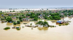
Image – Source
Uttar Pradesh, one of India’s most populous states, faces recurrent flooding primarily due to its location within the Ganga River Basin.
The Ganga and its tributaries, such as the Yamuna, Ghaghra, and Rapti, regularly overflow during the monsoon season, impacting vast swathes of the state.
The combination of natural factors, such as heavy rainfall, and human-induced challenges, like deforestation and urbanization, aggravates the flood situation.
Reasons for Flooding in Uttar Pradesh:
- Monsoonal Rainfall: The state experiences prolonged and intense rainfall during the monsoon, causing rivers to swell beyond their capacity.
- Overburdened River Systems: The Ganga and its tributaries carry massive water volumes, which often inundate the surrounding plains.
- Deforestation: Large-scale deforestation in the catchment areas of rivers has reduced water absorption capacity, increasing runoff.
- Unregulated Urbanization: Expanding cities and towns have encroached on floodplains, leaving little room for excess water to disperse.
Impacts of Flooding:
- Human Displacement: Millions of people are displaced annually, particularly in districts like Gorakhpur, Varanasi, and Allahabad (Prayagraj).
- Agricultural Losses: The fertile Gangetic plains, known as India’s “food bowl,” suffer significant crop losses due to waterlogging.
- Infrastructure Damage: Bridges, roads, and public buildings often become unusable after floodwaters recede.
- Health Crises: Waterborne diseases and sanitation challenges emerge as floodwaters stagnate in low-lying areas.
Mitigation Efforts:
Efforts to combat flooding in Uttar Pradesh include the construction of embankments, dredging of rivers, and flood forecasting systems.
However, experts emphasize the need for sustainable urban planning, afforestation programs, and the conservation of natural floodplains to reduce the recurring flood damage in the region.
4. West Bengal and the Sundarbans Region
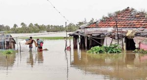
Image – Source
West Bengal, with its unique geographical location, is highly susceptible to flooding. The state experiences riverine, monsoonal, and coastal floods, particularly in the Sundarbans region.
The presence of major rivers like the Ganga, Hooghly, and Damodar, combined with the state’s proximity to the Bay of Bengal, makes it one of India’s most vulnerable areas to natural disasters, especially floods.
Reasons for Flooding in West Bengal:
- Monsoon and Cyclones: West Bengal experiences heavy monsoonal rainfall, and cyclones from the Bay of Bengal intensify flooding, especially in coastal areas.
- River Overflow: The Ganga, Hooghly, and their tributaries often breach their banks during the rainy season, inundating vast agricultural lands.
- Coastal Storm Surges: The Sundarbans, a UNESCO World Heritage Site, frequently faces storm surges and saltwater intrusion, damaging its ecosystem.
- Urbanization: Rapid development in cities like Kolkata has led to reduced natural drainage and frequent urban flooding.
Impacts of Flooding:
- Loss of Livelihood: The Sundarbans’ residents, dependent on agriculture and fishing, face devastation as floodwaters destroy crops and aquaculture farms.
- Ecosystem Damage: Saltwater intrusion from storm surges severely impacts the Sundarbans’ delicate mangrove ecosystem, threatening biodiversity.
- Human Casualties: Cyclones and floods often result in loss of life, with thousands displaced from their homes each year.
- Economic Losses: Infrastructure damage, particularly in low-lying areas, affects transportation and power supply, hindering recovery efforts.
Mitigation Efforts:
West Bengal has invested in embankments and cyclone shelters to mitigate flood impacts, particularly in the Sundarbans. Early warning systems and mangrove afforestation programs are also being implemented.
However, the growing impact of climate change poses a long-term challenge, requiring integrated efforts for flood prevention and coastal conservation.
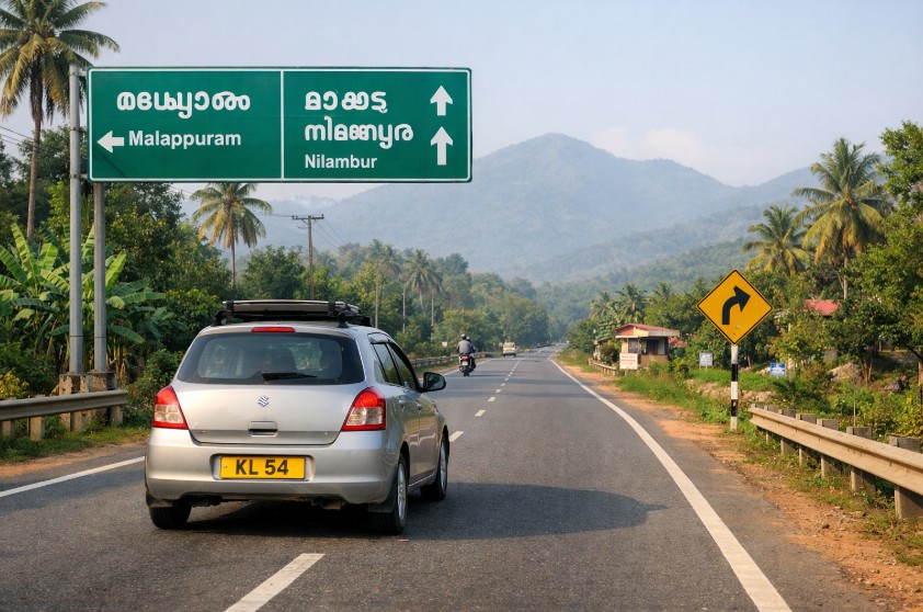
5. Kerala and the Coastal Plains
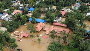
Image – Source
Kerala, often referred to as “God’s Own Country,” faces a dual threat of monsoon flooding and landslides, particularly in its coastal plains and highland areas.
The state’s unique geography, marked by its numerous rivers, backwaters, and proximity to the Arabian Sea, makes it highly susceptible to flooding. The catastrophic floods of 2018 brought global attention to Kerala’s vulnerability to extreme weather events.
Reasons for Flooding in Kerala:
- Intense Monsoon Rains: The state receives heavy rainfall during the southwest monsoon, with rivers such as the Periyar, Bharathapuzha, and Pamba swelling rapidly.
- Deforestation and Quarrying: Large-scale deforestation and illegal quarrying in the Western Ghats have increased soil erosion, leading to higher runoff and landslides.
- Urbanization: Rapid urban growth, particularly in low-lying areas, has reduced natural drainage capacity, worsening urban flooding.
- Climate Change: Rising sea levels and unpredictable rainfall patterns have increased the frequency and intensity of floods in the region.
Impacts of Flooding:
- Loss of Life and Property: The floods in Kerala often result in widespread loss of lives, displacement of thousands, and damage to homes and infrastructure.
- Agricultural Damage: Floods destroy paddy fields, plantations, and cash crops such as spices, a major source of livelihood for farmers.
- Landslides: The hilly terrain of the Western Ghats becomes prone to landslides during heavy rainfall, adding to the destruction.
- Economic Disruption: Tourism, a significant contributor to Kerala’s economy, suffers setbacks due to flooding and infrastructure damage.
Mitigation Efforts:
Kerala has prioritized the restoration of natural drainage systems and afforestation projects in the Western Ghats to combat flooding.
Community-based disaster management programs and advancements in flood forecasting systems have also been implemented. Despite these measures, the state faces ongoing challenges due to the impacts of global warming and unregulated development.
6. Mumbai and Urban Flooding
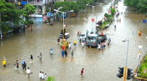
Image – Source
Mumbai, India’s financial capital, faces recurring urban flooding during the monsoon season. The city’s dense population, unplanned urbanization, and aging drainage infrastructure make it particularly vulnerable to waterlogging and flash floods.
Mumbai’s low-lying areas and proximity to the Arabian Sea exacerbate the impact of heavy rains, often bringing the city to a standstill.
Reasons for Urban Flooding in Mumbai:
- Heavy Monsoon Rains: Mumbai experiences intense rainfall during the monsoon season, often exceeding the city’s drainage capacity within a few hours.
- Coastal Location: Being a coastal city, high tides often coincide with heavy rains, preventing floodwaters from draining into the sea.
- Encroachment of Natural Waterways: Rapid urbanization has led to the reclamation of wetlands and the encroachment of natural water channels like the Mithi River, reducing their flood management capacity.
- Aging Infrastructure: Mumbai’s drainage system, originally built during the colonial era, is inadequate to handle the city’s modern-day demands.
Impacts of Urban Flooding in Mumbai:
- Economic Losses: The city often faces massive financial losses as transportation, businesses, and daily life come to a halt.
- Human Casualties: Flooding has led to tragic loss of lives, particularly in low-income settlements built in vulnerable areas.
- Health Hazards: Stagnant water creates breeding grounds for diseases such as malaria and dengue.
- Damage to Property: Floodwaters frequently inundate homes, vehicles, and infrastructure, leading to long-term recovery challenges.
Mitigation Efforts:
The Brihanmumbai Municipal Corporation (BMC) has implemented several flood mitigation measures, such as desilting drains, constructing pumping stations, and expanding the city’s stormwater drainage system.
However, experts stress the importance of restoring wetlands, regulating construction in flood-prone areas, and upgrading infrastructure to make Mumbai more resilient to urban flooding.
7. Punjab and the Sutlej-Beas Region
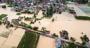
Image – Source
Punjab, known as the “Granary of India,” is frequently affected by floods, particularly in areas surrounding the Sutlej, Beas, and Ravi rivers.
The state’s agricultural prosperity often takes a hit due to recurring floods that damage crops, displace populations, and disrupt livelihoods. Punjab’s topography and extensive canal network, combined with monsoonal rains, contribute to its vulnerability to flooding.
Reasons for Flooding in Punjab:
- Overflowing Rivers: Heavy monsoonal rains often cause the Sutlej, Beas, and Ravi rivers to breach their banks, flooding the surrounding areas.
- Dam Releases: Sudden water releases from upstream dams, such as the Bhakra Dam, increase the risk of downstream flooding.
- Waterlogging: Poor drainage and excessive irrigation in some regions contribute to waterlogging, making agricultural fields prone to flooding.
- Encroachments: Encroachments on riverbanks and natural drainage systems have further aggravated flood risks.
Impacts of Flooding in Punjab:
- Agricultural Losses: Floodwaters often submerge large tracts of farmland, destroying crops like wheat, rice, and sugarcane, which are vital to the state’s economy.
- Economic Disruption: Damage to roads, bridges, and other infrastructure hampers transportation and trade, affecting the overall economy.
- Human Displacement: Floods displace thousands of people annually, particularly in rural areas, forcing them into temporary shelters.
- Health Challenges: Prolonged waterlogging leads to the spread of diseases such as cholera, dengue, and skin infections.
Mitigation Efforts:
The Punjab government has taken steps to mitigate flooding, including strengthening embankments, improving drainage systems, and implementing flood forecasting systems.
However, experts recommend better water management practices, afforestation in catchment areas, and stricter regulations against encroachments to reduce the recurring impact of floods in the Sutlej-Beas region.
8. Rajasthan and Flash Floods
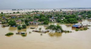
Image – Source
Rajasthan, known for its arid and semi-arid climate, is paradoxically prone to flash floods in certain regions. While the state is predominantly a desert, unexpected heavy rainfall events often lead to flash floods, causing significant damage to life and property. The phenomenon is particularly prevalent in low-lying areas, urban centres, and regions near water bodies like the Chambal and Luni rivers.
Reasons for Flash Floods in Rajasthan:
- Sudden Heavy Rainfall: Rajasthan occasionally experiences cloudbursts or intense monsoonal rains, overwhelming the soil’s absorption capacity.
- Desert Topography: The arid landscape and lack of vegetation reduce water retention, causing rapid surface runoff and flash floods.
- Urbanization: Unplanned urban growth in cities like Jaipur and Jodhpur has led to inadequate drainage systems, aggravating urban flooding.
- Dams and Reservoir Releases: Sudden water releases from dams, such as the Bisalpur Dam, can flood downstream areas.
Impacts of Flash Floods in Rajasthan:
- Infrastructure Damage: Roads, railways, and buildings in urban areas often bear the brunt of flash floods.
- Displacement of Populations: Flash floods displace rural and urban communities, forcing them into temporary shelters.
- Agricultural Losses: While the state’s agriculture is limited, heavy rainfall and flooding damage crops in regions dependent on irrigation.
- Economic Disruption: The state’s economy suffers as trade and tourism are hindered by flood-related damages.
Mitigation Efforts:
The Rajasthan government has focused on building rainwater harvesting structures and improving urban drainage systems to combat flash floods.
Programs promoting afforestation in catchment areas and maintaining the natural flow of rivers are being implemented. Despite these measures, Rajasthan’s flash flood incidents highlight the importance of robust early warning systems and sustainable urban planning.
9. Odisha and the Mahanadi Basin
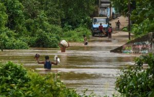
Image – Source
Odisha, situated along the eastern coast of India, is highly susceptible to both riverine and coastal flooding. The Mahanadi River Basin, covering a significant portion of the state, is often the source of widespread floods during the monsoon season. Additionally, Odisha’s location along the Bay of Bengal exposes it to cyclones, which exacerbate the frequency and intensity of floods.
Reasons for Flooding in Odisha:
- Heavy Monsoonal Rainfall: The Mahanadi and its tributaries, including the Brahmani and Baitarani rivers, overflow their banks due to torrential rains during the monsoon.
- Cyclones and Storm Surges: Odisha frequently experiences cyclonic storms that bring heavy rains and cause seawater to inundate low-lying coastal areas.
- Deforestation and Soil Erosion: Clearing of forests in the river catchment areas leads to increased soil erosion, which raises riverbeds and reduces water-holding capacity.
- Dam Releases: Unregulated water releases from upstream dams, such as the Hirakud Dam, often exacerbate flood conditions downstream.
Impacts of Flooding in Odisha:
- Human Casualties: Floods and associated cyclones have resulted in loss of life and large-scale displacement in many districts, such as Kendrapara, Puri, and Cuttack.
- Agricultural Devastation: Fertile farmlands are submerged for weeks, leading to the destruction of paddy and other crops, which are vital for the state’s economy.
- Infrastructure Damage: Roads, bridges, and communication networks suffer extensive damage, hampering relief efforts.
- Coastal Erosion: Frequent storm surges accelerate coastal erosion, threatening both communities and ecosystems.
Mitigation Efforts:
Odisha has implemented several flood control measures, including embankments, cyclone shelters, and flood forecasting systems. The state is also working on improving dam management protocols and promoting community-level disaster preparedness.
However, experts stress the need for reforestation in catchment areas, stricter regulations on land use in floodplains, and investment in climate-resilient infrastructure to better cope with recurring floods.
10. Chennai and the Adyar-Cooum Flood Zones
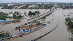
Image – Source
Chennai, the capital city of Tamil Nadu, faces recurring flooding challenges, particularly in areas near the Adyar and Cooum rivers. The city’s rapid urbanization, encroachment on natural water bodies, and insufficient drainage systems contribute significantly to urban flooding.
The devastating floods of 2015 highlighted Chennai’s vulnerability, causing widespread damage and drawing attention to the need for sustainable urban planning.
Reasons for Flooding in Chennai:
- Monsoon Rains: Heavy northeast monsoon rains, occurring from October to December, overwhelm the city’s drainage capacity.
- Encroachment on Water Bodies: Chennai’s wetlands, lakes, and rivers, including the Adyar and Cooum, have been encroached upon by urban development, reducing their ability to manage excess water.
- Poor Drainage Infrastructure: The city’s outdated and inadequate stormwater drainage system is incapable of handling intense rainfall events.
- Tidal Backflow: Proximity to the Bay of Bengal leads to tidal backflow during high tides, which hampers the natural drainage of floodwaters.
Impacts of Flooding in Chennai:
- Loss of Life and Property: Flooding often results in loss of lives and damages to homes, particularly in low-income settlements.
- Traffic and Economic Disruption: Flooded roads and halted public transport paralyze the city, affecting businesses and daily life.
- Health Hazards: Stagnant floodwaters contribute to the spread of diseases like leptospirosis and dengue.
- Environmental Degradation: Overflowing sewage systems and waterlogging lead to contamination of water bodies.
Mitigation Efforts:
Chennai has undertaken initiatives such as the construction of stormwater drains, restoration of wetlands, and periodic desilting of rivers to mitigate flooding. The Tamil Nadu government is also promoting sustainable urban planning by regulating construction in flood-prone areas.
Despite these measures, experts emphasize the importance of preserving natural drainage systems and improving community awareness to reduce the city’s vulnerability to future floods.
Conclusion
Floods remain one of India’s most devastating natural disasters, impacting millions each year. From the fertile plains of Bihar to the bustling streets of Mumbai, the recurring nature of these calamities highlights the need for proactive measures.
Addressing the root causes, such as deforestation, unregulated urbanization, and climate change, is essential to mitigate future risks. Strengthening infrastructure, restoring natural drainage systems, and empowering communities with disaster preparedness can make a significant difference.
By understanding the dynamics of flood-prone regions and implementing sustainable solutions, India can reduce the frequency and severity of these events, protecting lives, livelihoods, and ecosystems for generations to come.
FAQs About Top 10 Flood Prone Areas in India
Which state in India experiences the most frequent floods?
Assam experiences some of the most frequent and severe floods in India due to the Brahmaputra River and heavy monsoon rains. Other states like Bihar, West Bengal, and Uttar Pradesh are also significantly affected.
What are the major causes of urban flooding in cities like Mumbai and Chennai?
Urban flooding is primarily caused by unplanned urbanization, encroachment on natural drainage systems, inadequate stormwater infrastructure, and heavy monsoonal rainfall. Tidal backflow in coastal cities also contributes to the problem.
How does climate change affect flooding in India?
Climate change leads to more intense and unpredictable rainfall, rising sea levels, and melting glaciers. These factors exacerbate flooding, particularly in coastal and riverine regions.
What is the role of deforestation in increasing flood risks?
Deforestation reduces the soil’s ability to absorb water, increases runoff, and leads to higher sedimentation in rivers, raising their beds and increasing flood risks.
Why is Bihar’s Kosi River called the “Sorrow of Bihar?
The Kosi River frequently changes its course and overflows during monsoons, causing widespread destruction in Bihar. Its unpredictable behaviour has earned it the nickname Sorrow of Bihar.
What steps can be taken to prevent floods in India?
Measures include building better embankments, restoring wetlands and afforestation, improving urban drainage systems, implementing flood forecasting technologies, and stricter regulations against floodplain encroachments.
Are there successful examples of flood management in India?
Yes, some states have implemented effective flood management measures. For instance, Odisha has developed early warning systems and cyclone shelters that significantly reduce casualties during cyclones and floods.